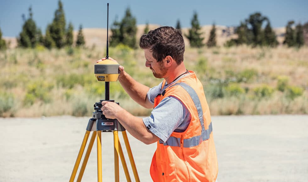
Anyone out on a surveying job in Alaska knows how tough it is to get precision data in harsh arctic conditions. And precision data is exactly what every surveying crew working in Alaska needs in order to get the job done right the first time. This is why – if you want that golf ball accuracy when capturing locations – you need to be using the right tools in order to save time (and money) on all of your remote large-scale projects.
With the advancement of technology, line-of-sight surveying methods are largely becoming a thing of the past. Though we’re not saying you should trash your theodolite or your measuring tape, taking advantage of modern tech – especially in the extreme conditions here in Alaska – will give you a huge advantage on each project your team takes on.
The advances in GNSS technology offer surveyors in Alaska the perfect solutions. And by using GNSS instruments, you and your crew can ramp up your surveying efforts and get the job done faster, and with greater precision.
Could your surveying crew benefit from GNSS technology? Contact GPS Alaska today to learn more.
What is a GNSS System?
A Global Navigation Satellite System (GNSS) is a satnav system that utilizes smaller orbital satellites in order to pinpoint and relay the location of the user’s GNSS receiver on the Earth. And the more satellites that you have access to, the greater your accuracy will be while surveying for a project.
In a nutshell, GNSS encompasses any constellation of satellites in orbit that are used for positioning purposes. For example, the four primary GNSS constellations used across North America include:
- American constellation – GPS (Global Positioning System)
- European Union constellation – Galileo
- Russian constellation – GLONASS
- Chinese constellation – BeiDou
Today, GNSS instruments can be acquired by anyone with the need for global location tasks, and these tools are especially helpful for tracking movement, pinpointing locations, and surveying needs in complex terrain where line of sight is essentially non-existent – particularly out here in the Arctic.
How Does GNSS Surveying Work?
If you’ve ever tried to use your phone for pinpointing your exact location, you may have learned that this isn’t the most accurate. While your location will be determined through the GPS board in your phone, the precise location with pinpoint accuracy is largely missing. In fact, it could be determining your location as far away as 30 feet or more.
When satellite signals pass through the atmosphere, they become bent, distorted, or can disappear altogether. A GNSS receiver relies on these signal chains to interpret real-time location data. And when it comes to surveying, pinpoint accuracy is critical for large-scale projects. As such, if you want to get the golf ball accuracy that a GNSS receiver provides, this will require a correction system – a second receiver that essentially tells the first receiver where it is.
Once the GNSS receiver has the right data, it will transmit this location to the rover, or to a machine control system that will interpret the data captured by the receiver to determine their position – or positions of boundaries, objects, points, or forms relative to the project.
GNSS Benefits for Alaskan Surveyors
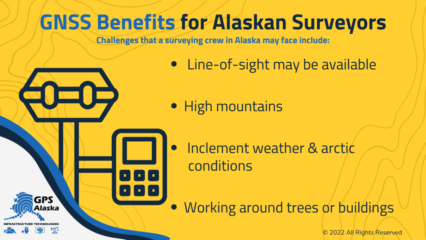
As mentioned, Alaska is a land of extremes, both in climate and weather as well as terrain and topography. And these challenges can be limiting for any surveying crew – no matter how experienced or skilled. As such, the use of GNSS can be extremely beneficial for a surveying crew collecting data and performing work in the harsh conditions of the 49th state.
As a field or construction surveyor, precision is key to working accurately and efficiently while increasing profitability. And when you utilize GNSS tools that provide reliable results, your efforts while working out in Alaska will be made much easier.
A few challenges that a surveying crew in Alaska may face include:
- Line-of-sight may be unavailable
- High mountains
- Inclement weather & arctic conditions
- Working around trees or buildings
While the primary benefit of GNSS surveying tools offers the Alaskan surveyor access to satellite constellations orbiting the Earth – particularly those passing directly over the continent this also offers greater reliability and precision.
Additional benefits also include the ability to operate without line-of-sight, across water bodies, and within areas where obstructive boundaries are present. And as all Alaskans know, the extreme terrain found here can make any surveying project a challenge without the appropriate tools.
Tools for Alaskan Surveyors
Here at GPS Alaska, we offer the field or construction surveyor a variety of GNSS tools that can improve both the quality of work and your overall productivity and time management. With tough instruments from Topcon and other manufacturers, you can rely on GPS Alaska for the tools that you need to get the job done right the first time. And out here in Alaska, this is an advantage in itself.
Our popular GNSS tools include:
- HiPer HR – a multi-purpose Topcon GNSS receiver equipped with an advanced Fence Antenna with 9-axis TILT™ compensation
- HiPer VR – A compact Topcon GNSS receiver including an integrated IMU, eCompass and equipped with universal tracking tech
- TopNET Live Alaska – A subscription-based, GNSS referencing network that delivers accurate Network RTK correction data to keep your location precise to golf ball sized radius
While anyone working out in Alaska needs to have reliable equipment, durability is also an essential quality. With the extreme conditions present near the arctic circle, having both is going to be an asset for you and your surveying crew. And this is why you should rely on GPS Alaska because we stand behind all of our GNSS products.
Improving Accuracy and Productivity With GNSS Tools
GNSS tools will not only make your life easier, but they will also make your crew’s job much easier to manage and perform. And in addition to reducing manual labor, using GNSS may also reduce the amount of work you and your surveying crew need to perform out in the harsh Alaskan environment.
Surveyors may also be able to rest easy knowing that correction data is being relayed in real-time, making it a cinch to take precise measurements for road building, underground support structures, and any other project that requires precise data. And this may also ensure that your projects will be completed with far fewer man-hours than would typically be needed when relying on larger crews using traditional surveying equipment.
At the end of the day, GNSS technology allows for greater precision in both geodesic and topographical surveys. With greater precision and reliability, you and your crew will be able to get accurate results in less time – even under the most extreme conditions.
Alaska is a land of extreme conditions. And unless you’re using the right tools, you’ll likely need a much larger crew to execute even the smaller jobs out in the Arctic. You’ll also be plagued by inclement weather and land obstructions that make collecting data difficult if not impossible. And this is why relying on GNSS technology can not only improve your overall efforts, it can increase profitability while also improving the safety of your crew while they operate out in the tough Alaskan terrain and climate.
Could GNSS technology help your productivity with surveying? Contact GPS Alaska today to learn more.